러시아 직경 100m ‘미스터리 구덩이’ 정체 밝혀져
입력: 2014.07.19 17:18
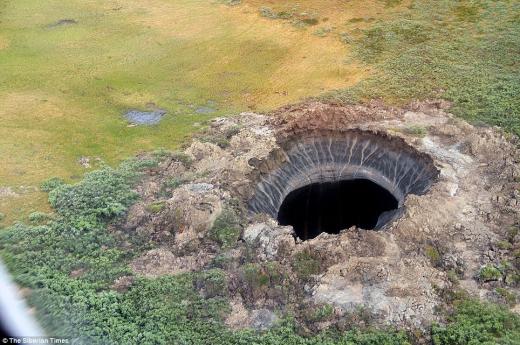
최근 러시아 시베리아에서 발견된 직경 100m 크기의 신비한 구덩이의 정체가 밝혀졌다.
이 구덩이가 발견된 지역은 러시아 북쪽 끝 ‘야말’이라는 지역으로, 겨울에는 기온이 영하 50도까지 떨어지고 태양도 거의 볼 수 없는 극한의 환경을 가졌다.
당시 현지 언론 뿐 아니라 네티즌들은 이 구덩이가 운석이 떨어지면서 그 충격으로 생긴 구멍일 것이라는 추측을 내놓았다.
또 이 지역 인근에 있는 러시아 최대의 보나벤트스키 가스층의 가스가 폭발하면서 생겼을 가능성도 제기됐다.
하지만 전문가들은 최근 지표면에 충격을 줄 정도의 운석이 떨어지지 않았으며, 가스 폭발의 흔적도 찾을 수 없다고 발표해 의문은 더욱 커졌다.
미스터리한 구덩이를 조사한 러시아 과학자들은 이 구덩이가 운석 때문이 아닌 급격하게 상승한 기온 때문이라고 결론지었다.
북극 과학연구센터의 연구원인 안드레이 플레하노프는 “최근 이 지역의 기온이 변하면서 지반이 큰 압력을 받았다”면서 “구덩이 근처에서 심하게 그을린 흔적 등을 발견했다”고 설명했다.
지구온난화로 지반과 가스, 소금층 등이 압력으로 폭발했을 가능성이 높다는 것.
현지 연구팀에 따르면 이 지역은 1만 년 전 바다였다가 지반이 융기하며 대지로 변했다. 때문에 해저지역이 주로 함유하고 있는 가스, 소금 등의 성분이 풍부한데, 기온이 높아지면서 이들 성분들이 유기적으로 압력을 받은 것으로 보인다.
현재 연구팀은 이 미스터리 구덩이에서 채취한 다양한 샘플을 통해 더욱 자세한 연구를 진행하고 있다.
나우뉴스 송혜민 기자 huimin0217@seoul.co.kr
http://nownews.seoul.co.kr/news/newsView.php?id=20140719601009
미국 절반이 흔들리고, 부서지며 지진위험이 커지다
Shake, rattle and roll: Earthquake risk increased for half of US

The US Geological Survey (USGS) is predicting where earthquakes will occur over the next 50 years, how often they will happen and how hard the shaking will be. About half the country has an increased risk of experiencing seismic activity.
The USGS predictions run 50 years because that is the typical lifetime of a building, the agency said in a blog post. During that time, 42 states have a “reasonable chance of experiencing damaging ground shaking from an earthquake,” while 16 states have a “relatively high likelihood” of such a seismic hazard.
The states most likely to have a damaging earthquake are: Alaska, Arkansas, California, Hawaii, Idaho, Illinois, Kentucky, Missouri, Montana, Nevada, Oregon, South Carolina, Tennessee, Utah, Washington and Wyoming.

위의 도표중 붉고 자주빛으로 나타난 지역은 아주 강한 지진발생이 2%로 예보되었다.
The highest risk places have a 2 percent chance of experiencing "very intense shaking" over a 50-year lifespan, USGS project chief Mark Petersen said to the Associated Press. Those with lower hazard ratings would experience less intense swaying measured in gravitational force.
"These maps are refining our views of what the actual shaking is," Petersen said. "Almost any place in the United States can have an earthquake."

A damaged stone angel is pictured on the roof of the main tower of Washington's National Cathedral after an earthquake. (Reuters / Jason Reed)
That point was brought home by the August 2011 earthquake in Mineral, VA. The magnitude 5.8 quake, whose epicenter was placed at Mineral, Virginia, was felt across the East Coast, with reports of tremors stretching from North Carolina to Rhode Island, New York City to Cleveland and even in Toronto, ontario, Canada. It was among the largest earthquakes to occur along the Eastern Seaboard since 1897, and helped scientists determine that even larger events are possible. Estimates of earthquake hazards near Charleston, SC, have also gone up due to the assessment of earthquakes in the state, the USGS said.
In California, earthquake hazard extends over a wider area than previously thought. Scientists discovered new faults in the Golden State, increasing the risk of quakes in San Jose, Vallejo and San Diego. At the same time, though, the risk was decreased the risk estimates for Irvine, Santa Barbara and Oakland, although the greater San Francisco Bay area is more likely to experience intense seismic activity than the USGS predicted in 2008 - the last time the maps were updated.
The maps are important for planning for the future, especially when it comes to building codes.
“The standards for seismic safety in building codes are directly based upon USGS assessments of potential ground shaking from earthquakes, and have been for years,” Jim Harris, a member and former chair of the Provisions Update Committee of the Building Seismic Safety Council, said in the USGS blog post. “The committees preparing those standards welcome this updated USGS information as a basis for making decisions and continuing to ensure the most stable and secure construction.”
While hydraulic fracturing - or fracking - has been linked to increased seismic activities in states like Oklahoma, Idaho, Ohio and Texas, the USGS said it is still researching “induced earthquakes,” or those events that “may be associated with human activities such as the disposal of wastewater in deep wells.” (So far this year, nearly 250 small to medium quakes have hit Oklahoma.)

Petersen told AP that the maps sidestep the issue of earthquakes created by injections of wastewater from oil and gas drilling, and those extra quakes weren’t included in the analysis.
“One specific focus for the future is including an additional layer to these earthquake hazard maps to account for recent potentially triggered earthquakes that occur near some wastewater disposal wells,” the USGS said. “Injection-induced earthquakes are challenging to incorporate into hazard models because they may not behave like natural earthquakes and their rates change based on man-made activities.”
Some localities in the US aren’t waiting for government seismologists to confirm the link between quakes and fracking or to add those events to their maps, though. Several places in California, including Beverly Hills and Santa Cruz County, have already banned hydraulic fracturing, and similar bans and moratoriums are being discussed in areas of Texas, Colorado, Massachusetts, New York, Pennsylvania and Ohio.
'지구촌 얘기들 !' 카테고리의 다른 글
| + 그속엔 바다가 있을까?…목성 위성 유로파, 얼음 표면 공개 (0) | 2014.07.22 |
|---|---|
| + 외계인·UFO?…인도서 1만년 전 ‘미스터리 벽화’ 발견 / 외계 생명체 탐색 (0) | 2014.07.22 |
| + “태양이 고요해졌다”…흑점 사라진 미스터리 현상 - 지나치게 조용해졌다 (0) | 2014.07.21 |
| + 화성에서 지구유사 토양 발견…가장 강력한 생명체 증거 (0) | 2014.07.21 |
| + 미국의 해외 영향력은 증발하고 있는 중이다. US influence abroad is evaporating (0) | 2014.07.21 |
| + 반인반마(半人半馬) 우주에 나타나다… 환상적인 ‘궁수자리’ (0) | 2014.07.18 |
| + 소행성에서 ‘피라미드 물체’ 발견 - 광물 캐는 탐사선 보낼 계획 (0) | 2014.07.17 |
| + UFO 뉴스 / 움직이는 별자리?…밀라노서 ‘희귀 UFO’ 약 50분간 떠있어.. (0) | 2014.07.17 |
| + “후지산 폭발, 위험한 단계”…대재앙 발생할까 - 곧 분화 불안감... (0) | 2014.07.17 |
| + UFO 뉴스 / 태양 주변에, 달에도, 화성에도, 지구촌 상공의 UFO 들 무지 뜨네요 !! (0) | 2014.07.17 |